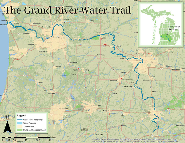
Involving local communities and spreading the word about improved water quality, the Grand River Partnership (GRP) is working to have all 252 miles of the Grand River designated as either a state or federal water trail, from its source near Jackson to its mouth at Grand Haven.
Spread the word! The Grand River is once again a great place to paddle. In order to share that good news, the Grand River Partnership (GRP) is working to have all 252 miles of the river designated as either a state or federal water trail, from its source near Jackson to its mouth at Grand Haven. Consisting of the
Lower Grand River Organization of Watersheds (LGROW), the
Middle Grand River Organization of Watersheds (MGROW), and the
Upper Grand River Watershed Alliance (UGRA), GRP is seeking to involve communities along the entire length of the river.
The
State of Michigan already boasts 3,000 miles of water trails: designated routes along a lake, river, canal or bay designed for kayaks, canoes, single sailboats or rowboats. Also called blueways, they are the aquatic equivalent of a hiking trail.
“A water trail is different from a river in that it is designed for some type of experience—a natural resources, culture, or history focus,” says Elaine Sterrett Isely,
West Michigan Environmental Action Agency (WMEAC) director of water programs. "A water trail implies that someone is taking on the responsibility of maintaining access points and you can find information on how long between access sites, what you can expect to find, and that kind of thing.”
![]()
The river that attracted Grand Rapids’ founders has served many purposes throughout the centuries. Indigenous people living in the region relied on the Grand for food and as a trade route. Europeans colonizing the continent navigated it in explorations and in the exploitation of virgin forests as it became a means to transport timber. As the 20th century unfolded, cities and industry used it less for transportation and more to dispose of wastes.
As environmental consciousness rose, so did concern for the Grand. Municipalities like Grand Rapids and organizations like WMEAC began taking action to improve the river’s polluted waters. In April 2017, the
City celebrated a new $400 million combined sanitary sewer system that no longer dumped sewage into the Grand.
Now that the Grand’s
water quality has been somewhat restored, GRP’s member organizations want to keep it that way. They believe that when people paddle and play on the Grand, they will support efforts to improve not only its waters, but water quality across the state.
“The more people use it, the more they’ll understand why water quality is important. It’s another way to talk about water quality that’s more fun,” Isely says. “It opens up the conversation about why what we do on the land can improve the water.”
![]() From Jackson to Grand Haven
From Jackson to Grand Haven
Fred Cowles, president of MGROW, agrees that getting people to experience the river’s beauty will inspire them to take political and social action to both improve water quality and address the entire natural environment.
“We focus on the water environment although everything is connected,” he says. “Climate change is the greatest threat to water quality but not the most immediate. What happens on the land is what determines water quality—farms, factories, roadways—people have made fundamental changes to the landscape.”
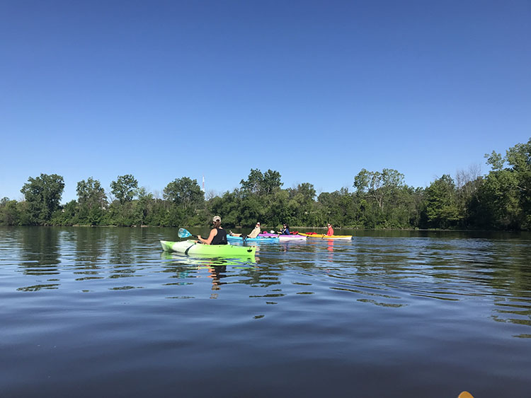
When the Grand is a designated water trail, paddlers will be assured of good access and launch points, amenities like restrooms, proximity to restaurants or campgrounds, and information that helps them plan a safe river adventure—for example, online guides, waterproof maps, signage, or aps.
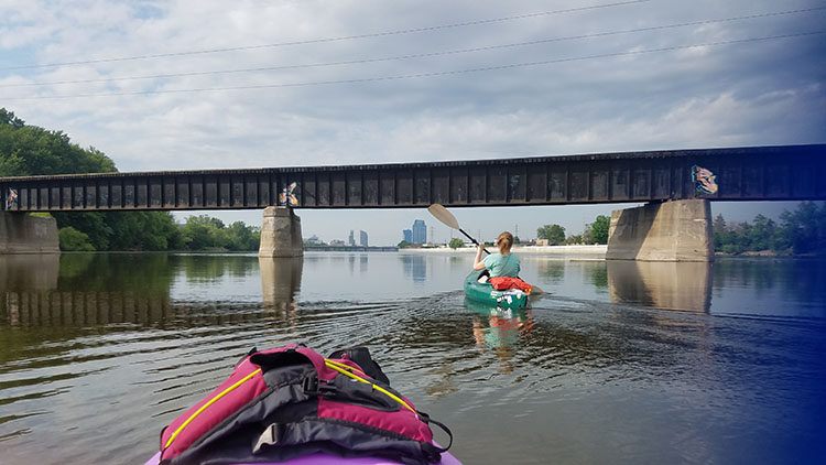
MGROW, which addresses the Grand River from Eaton Rapids, through Lansing, and on to Lyons, has self-designated the
Middle Grand River Heritage Water Trail for its portion of the Grand. Its informational stratagem is now up and running. Cowles notes that MGROW’s work has led to more canoe liveries opening on the Grand in and near Lansing—and a lot more kayaks and canoes on the river.
![]()
“A few years ago, we put together a guidebook with water resistant paper maps with mileage and launch information, kinds of things people need to know when planning a trip on the river. Points identified were hazards, access points, and heritage points,” he says. “Our web page offers more information. And, we’ve got a smartphone app that will act like a GPS and tell you where you are on the river.”
Ottawa County has already designated
The Grand River Heritage Trail along its portion of the river. Its online guide provides information about river access points, natural features, historical points of interest, county parks, and open spaces where paddlers can stop.
Meanwhile, back in the River City...
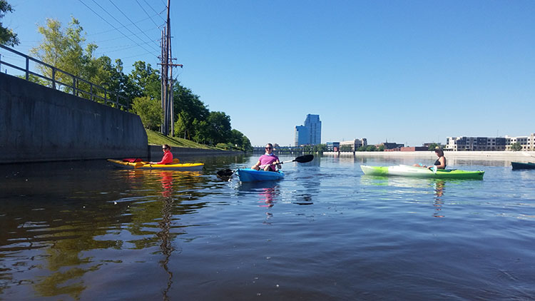
As director of environmental programs for the Grand Valley Metro Council, Wendy Ogilvie helps oversee LGROW and offers staff support to the water trail project. She notes that one of LGROW’s tasks is getting more Kent County communities on board and developing more access points to the river.
“Because we have all the communities as members, the Metro Council’s role has been to connect and educate—and get resolutions of support,” she says. “We want to show them that they have a huge resource—but if they don’t have any place for people to access the river, they are losing opportunities.”
An avid paddler, Rachell Nagorsen, City of Walker engineering programs coordinator, notes that as a member of the Metro Council, Walker is taking steps to improve water quality in Indian Creek, a tributary to the Grand. On a personal level, she looks forward to a water trail designation that ensures readily available paddling information.
“Looking for places to paddle in Kent County takes a lot of time on Google. When you do find resources, you don’t know if they are up-to-date. I’d really like to be able to get to that central location to have all that information.”
![]()
Meanwhile, LGROW is researching signage options, how to provide safety information, and developing an overall planning document for the lower Grand River.
“MGROW is just finishing up their plan. Ottawa County has a pretty good plan. We don’t have a plan for Kent and Ionia counties. We need to make sure that the (downtown Grand Rapids)
rapids restoration is on its way and see what kind of access points will be part of that project. So many dams are in the river there now.”
“One of the other things LGROW is doing is talking to communities along the river. We’re asking city commissions for resolutions of support,” Isely adds. “We’ve obtained them from Boston, Lowell, Walker, Ionia County, Saranac, as of today, Ada. There are several we haven’t spoken to yet. Cascade and Portland are on the agenda.”
Lansing and the Grand
As LGROW, MGROW, and UGRA work to achieve state or federal water trail designation for the Grand, they face the fact that state funding has dried up. However, since water trails can bring tourism and recreation dollars to municipalities, these groups hope the State will see the value in funding the project.
“We need funding. People can donate—and they can encourage the State to put some funding behind their words. Every ad for
Pure Michigan talks about our waterways but there is no state funding for water trails.”
Tight budgets aren’t holding back GRP members from moving their plan forward. Every ten years,
the Grand River Expedition paddles the river from Jackson to Lake Michigan. During the 14-day voyage and camp-out, the huge flotilla raises awareness of the river and monitors water quality. In 2020, members of LGROW, MGROW and UGRA would like the Expedition to take place on a designated water trail.
Wouldn’t that be grand?
Photography by Wendy Ogilvie, Grand Rapids Metro Council.