There are several examples of applied modern mapping technology in West Michigan alone, and one need look no further than the City of Grand Rapids' technology department for examples.
The concept of mapping technology is and always has been a part of human culture. It's one of our oldest technologies, yet we find new ways of designing and using maps to this day.
At the most basic level, a map explains the spatial relationships between different points. We use them every day to get around town and many people, with the help of a smart device, may think nothing of it. Anyone who's looked up directions to a restaurant understands that an address can contain a wealth of information, but there are other ways of embedding maps with information that show important trends.
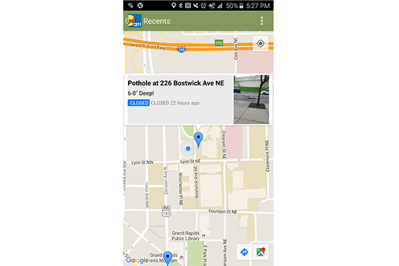
There are several examples of applied modern mapping technology in West Michigan alone, and one need look no further than the City of Grand Rapids' technology department for examples. The GRCity 311 mobile application allows anyone with an Apple or Android smartphone to report pot holes, graffiti, street light problems, and other issues directly to the city's Citizen Request Management system. Users can submit a problem with or without geotagged images, receive a ticket for the problem, and
track the progress of the problem until it is resolved.
![]()
The Grand Rapids Police Department's
crime mapping program provides public access to the past 90 days of crime information in the City of Grand Rapids. You can basically see where preliminary crime reports were made by GRPD officers. As those reports produce arrests or other results, the classification of the plotted points can change. The GRPD adds a disclaimer to its mapping feature, and warns that the information is only approximate, but it does offer a unique way to see local trends in crime.
Perhaps the most exciting of all is Grand Rapids' Enterprise
Geographic Information System, which is sharing information between city departments and the community. The Grand Rapids Open Data catalog is a collaborative project between the City of Grand Rapids and
Friendly Code, a
Code for America Brigade. Through this collaboration, we're seeing more than just municipal borders.
Historic landmarks and the stories of our
modern streets are being mapped out in real time.
Earlier this year we covered a project called
Radi8er that took mapping technology and enhanced it with overlays of musical preference and regional artists to provide a unique way to find music. The app is still in
beta testing but it's available for iPhone and Android, so we will be playing around with it heavily and report back in a few weeks!
Urban Innovation Exchange highlights the people and projects transforming West Michigan through sustainable efforts. To see more UIX stories, you can check out the entire series here. Have thoughts or ideas about UIX? Contact UIX Grand Rapids Editor Matthew Russell at [email protected].
Enjoy this story?
Sign up for free solutions-based reporting in your inbox each week.