June 25, 2021.
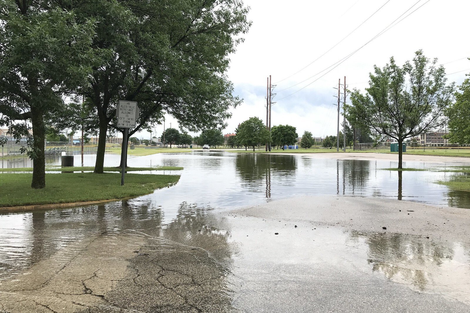
It took just a single summer rainstorm to wreak havoc on the city of Detroit’s homes and highways. Across the city and its suburbs alike, stormwater and sewage backed up into home basements, ruining appliances and furnishings.
Cars were abandoned, many completely submerged, on flooded freeways — some of which wouldn’t reopen for days.
Two years later, longer-term impacts on public health and infrastructure are still not fully known.
One city.
One storm.
One antiquated municipal stormwater system designed to handle rainfall based on precipitation volume estimates that no longer apply.
The worst part? These heavy rainfall events are increasing, in both frequency and intensity, across the Great Lakes Basin, and Detroit is one of many cities whose capacity to handle those events is faltering.
The good news? There’s relief in sight — management systems that use Nature’s own defenses to help lighten the burden.
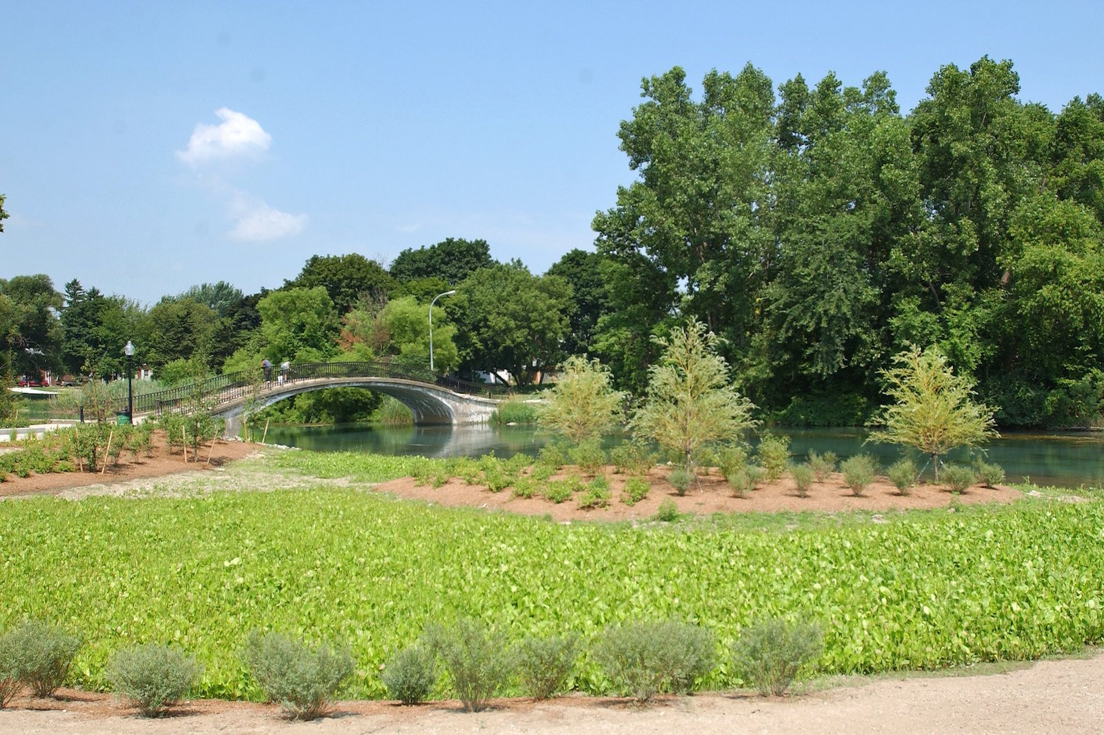
![]() Elizabeth Park in Trenton was revitalized and now demonstrates ways to control water after a rain. Photo courtesy Todd Marsee, Michigan Sea Grant
Climate change demands system changes
Elizabeth Park in Trenton was revitalized and now demonstrates ways to control water after a rain. Photo courtesy Todd Marsee, Michigan Sea Grant
Climate change demands system changes
Across the Great Lakes basin scientists and planners are pivoting to re-examine alternative drainage systems and to address barriers — including obsolete data — that may stand in the way of innovative, sustainable green designs.
In March 2023, a
Great Lakes Protection Fund supported network of Great Lakes region’s resilience and sustainability leaders, called
Resilient Infrastructure Sustainable Communities or RISC, released a report titled
Climate Change Preparedness of Great Lakes Communities. This report examined changing rainfall amounts across five cities in the Great Lakes region, to understand whether the regulatory permits and community planning efforts are aligned with robust and current rainfall estimates. Their analyses found that between 1961 and 2020, the City of Chicago has seen nearly a 30 percent increase in 10-year 24-hour storm precipitation frequency estimates and a 50 percent increase in 100-year 24-hour storm precipitation frequency estimates.
So far as future projections, for the mid- (and late-) century estimates, rainfall estimates are expected to increase: In Chicago, the rainfall amount is expected to increase by 15 percent by mid-century, and 20 percent by the end of the century.
In Buffalo, N.Y., the rainfall amount is expected to increase by 10 percent by mid-century, and 21 percent by the end of the century.
And in Detroit, a city that’s already struggling? The rainfall amount is expected to increase by a whopping 67 percent by mid-century, and 138 percent by the end of the century.
“These are massive changes,” says Sanjiv K. Sinha, Ph.D., lead author of the RISC report and the Chief Executive Officer of Corvias Infrastructure Solutions, LLC (CIS).

![]() Sanjiv K. Sinha, Ph.D., Chief Executive Officer of Corvias Infrastructure Solutions, LLC.
Sanjiv K. Sinha, Ph.D., Chief Executive Officer of Corvias Infrastructure Solutions, LLC.The implications are bleak, he says, “especially when you realize that stormwater/CSO permits across the region were issued many years ago, and they used rainfall estimates from a decade or more ago. Updating these permits to address the impacts of extreme, future rain events is crucial to managing the associated risks.”
There are so many more risks than the blocked roadways that might be the first thing people think of when it comes to flooding.
“Remember that flooding is not just a transportation problem,” he says, “it is a critical public health problem that impacts the vulnerable, lower-income citizens harder.”
How storm drains and sewers work
Managing rainfall and drainage is an underpinning of municipal development dating back many decades.
When they work well, the systems traditionally used to drain rainwater from city streets and parking lots are almost invisible in their simplicity.
Water runs from rooftops through downspouts, directed away from homes and businesses. Paved streets, crowned higher in the middle than along the edges, channel water to curbs and gutters, where it flows through grates and into underground pipelines or tunnels and eventually empties into local streams, rivers, or lakes. Paved parking lots and construction sites include drains to prevent water from gathering in giant puddles.

![]() A green roof on the Milwaukee Public Library also helps capture water every time it rains. Photo courtesy MMSD
A green roof on the Milwaukee Public Library also helps capture water every time it rains. Photo courtesy MMSD
Because that stormwater carries with it the trash, sediment, lawn chemicals, oil from roadways, and other pollutants it passes over along the way, municipal storm runoff is regulated by state and federal environmental protection agencies to safeguard the surface waters receiving them
. Local codes and zoning ordinances guide development as well.
Many municipalities currently use combined sewers, in which storm drains carrying rainwater and sanitary sewer lines — those running from kitchens, bathrooms, and laundries — are connected. Those systems are likewise regulated and their waters treated to remove pollutants, according to the parameters of their permits, before they are allowed to be discharged.
What happens when the system fails

![]() Peter Larson, an epidemiologist at the University of Michigan
Peter Larson, an epidemiologist at the University of MichiganThe traditional sewer and drainage infrastructure has generally worked so well for decades that it is taken for granted — until it fails.
“I mean, most people don't know what happens when they flush the toilet,” says Peter Larson, an epidemiologist at the University of Michigan who has studied the public health problems associated with flooding.
Combined systems intended to handle the water from both storm runoff and sewers might occasionally fail if a piece of equipment breaks, or a drain becomes clogged.
More frequently, those failures are beginning to happen when the systems are simply overwhelmed, unable to handle the water rushing into them.
Storm drains are built to handle average rainfall; sanitary sewer volumes are determined by population.
When either, or both, of those conditions increases, the system is pushed to its limits or beyond. That's why heavy rains of several inches are hard for stormwater systems to manage. If the quantity of stormwater exceeds the capacity of a wastewater treatment plant to process the water, flooding or releases of untreated wastewater through combined sewers can result — backing up through the very pipes that are supposed to carry the water away.
Americans use an average of 82 gallons of water a day at home, according to the
US Geological Survey, Estimated Use of Water in the United States in 2015.
Every new home added to a municipal sewer system means more toilets flushing, more showers, dishwashers, and washing machines draining.

![]() Erica Clites, Michigan State University Extension Program Worker
Erica Clites, Michigan State University Extension Program WorkerBut indirectly, population growth also impacts stormwater “through the creation of additional impervious surfaces such as buildings, sidewalks, driveways and parking lots,” says Erica Clites,
Michigan State University Extension Program Worker. This is especially true, she says, if natural areas, which soak up
water well, are converted into impervious surfaces.
Even if a city’s population has remained stable or decreased, rainfall has not. Climate changes have seen cities in the Great Lakes Basin experience more frequent heavy rainfalls and that trend is continuing.
The number of
heavy precipitation events in the Great Lakes region increased 35 percent from 1951 to 2017, Clites says.
As stormwater infrastructure ages, it is increasingly unable to handle current conditions.
That summer rain that rocked Detroit in 2021 is a stark example of how simply too much water, coming too fast, can devastate infrastructure within hours.
When more than 6 inches of rain fell in 12 hours, a state of emergency was declared for Detroit and surrounding Wayne County following that June 25, 2021 storm. Two weeks later, Michigan Congresswoman Debbie Dingell
reckoned floods had damaged more than 12,000 homes in Detroit, and as many as 20,000 in suburban Dearborn.
Property damages in excess of $139 million were reported through the
National Center for Environmental Information.
The impact of those overflows goes beyond a few days of flooded streets snarling traffic. Homeowners were left holding the tab for damages not covered by their homeowner’s insurance.
In addition to their anxiety, there’s the hidden public health impact of illness associated with exposure to sewage and the exacerbation of non-communicable respiratory diseases such as chronic obstructive pulmonary disease (COPD), asthma, and allergies.
Public health
It doesn’t take an outbreak of cholera for flooding to exact a public health toll.
Peter Larson, an epidemiologist at the University of Michigan, says flooding has wide-ranging social, economic, and public health impacts, particularly for people in poor communities.
Again, consider Detroit, a city with one of the highest asthma rates in the country. Though the exact reasons for that are unknown, Larson says, one reason to speculate is that Detroit is continually flooded.
“The 2021 flood was extreme — but there are these ‘mini floods’ that happen all the time,” Larson explains. “So when you get some kind of rain event, the system becomes overtaxed and then sewage backs up into the home.”

![]() Rain garden with drain is another recommended way to deal with water after a rain. Photo courtesy Michigan Sea Grant.
Rain garden with drain is another recommended way to deal with water after a rain. Photo courtesy Michigan Sea Grant.There are people in Detroit who live with a couple of inches of water in the basement all year round. Larson says. “That long story short, you know, could be a possible explanation for why Detroit's asthma rates are so incredibly high.
So while the extreme rainfall of that single storm exacted an extreme toll, so, too, does the chronic pressure of ever-increasing precipitation.
“I sort of want to divorce the idea that 2021 was a one-time event, and really draw attention to the fact that flooding in Detroit is a year-round continuum,” Larson says. “And people are facing impacts from that all the time” — long-term documented impacts on their respiratory and cardiovascular health.
Though the 2021 Detroit flood presented a high-profile urban example, Larson says, “people have to sort of stop viewing this as a local problem and view this as a statewide problem that we need to address. These problems are all our problems.”
“I'm an epidemiologist. I would maintain that flooding is a major public health issue and we should address it like any other public health issue and work on the policy level to improve the lives of people at risk.”
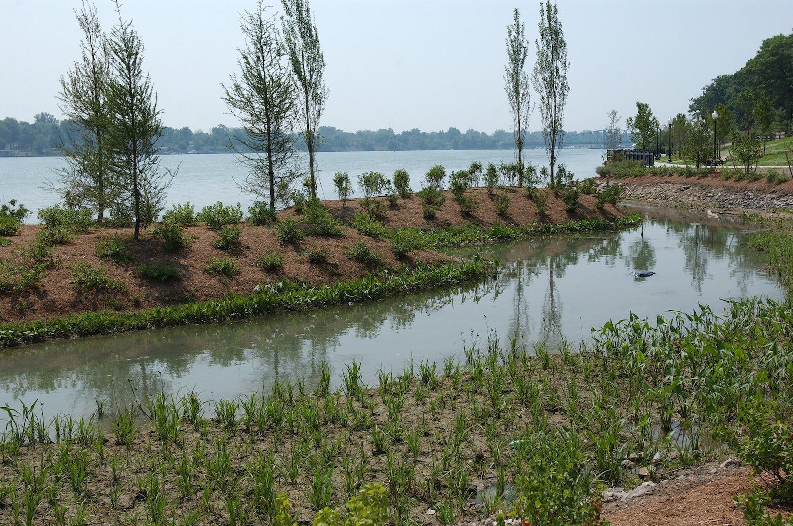
![]() Native plants and earthen solutions were used to create a natural buffer on the banks of the Detroit River at Elizabeth Park in Wayne County. Courtesy Michigan Sea Grant
An anomaly, or the new norm?
Native plants and earthen solutions were used to create a natural buffer on the banks of the Detroit River at Elizabeth Park in Wayne County. Courtesy Michigan Sea Grant
An anomaly, or the new norm?
Whether it’s human health or homes and highways at risk, the message that flooding is a costly and increasingly frequent problem in urgent need of solution is beginning to sink in.
The June 2021 Detroit downpour was “far beyond the capacity” of the area’s stormwater system to handle, the city’s mayor said, also the conclusion reached a year later by the Great Lakes Water Authority, as it rejected all of the claims against the utility for damages related to the storm. An
independent engineering report concluded the flooding was caused not by any defect in the system’s operation, but by too much rain for the system — or any other collection system “designed to today’s standard” — to handle.
And Detroit is not alone — similar rampant flooding is now a common occurrence across Great Lakes cities.
As bad as the recent past has been, the future seems more dire as forecasts of future event precipitation amounts are significantly more than they are today, suggesting the impacts of storms will continue to get worse.
Adjusting to change
So how can municipalities catch up with the changes required to handle extreme weather swings?
Clites says replacing all the stormwater infrastructure and/or continuing to build it to accommodate larger and larger flows is increasingly unsustainable.
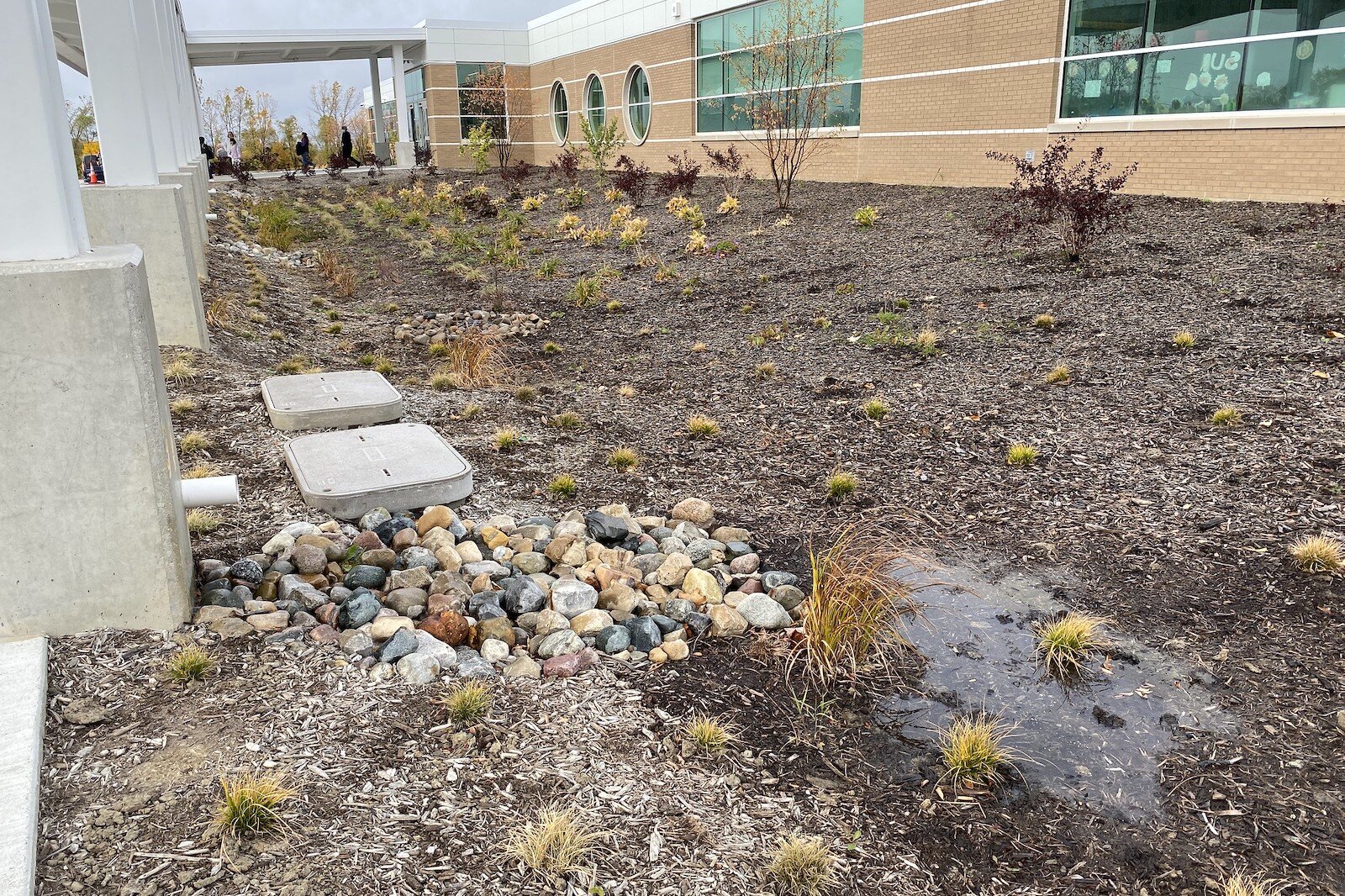
Many municipalities are instead seeking to divert stormwater from the older systems by adding green infrastructure — such as green roofs, rain barrels, permeable pavement, and streets lined with trees — to reduce the demand on the drains and storm sewers.

![]() These pavers help capture water when it rains. Photo courtesy Michigan Sea Grant.
These pavers help capture water when it rains. Photo courtesy Michigan Sea Grant.Green infrastructure, Clites explains, helps reduce the contaminants entering natural water bodies by filtering the stormwater through the soil, removing many of the contaminants.
By restoring wetlands, forests, and buffers to retain and infiltrate stormwater, green stormwater infrastructure is designed to mimic nature and capture rainwater where it falls.
Like a sponge, green infrastructure reduces and treats stormwater at its source.

![]() Sridhar Vedachalam, Ph.D., director of Water Equity & Climate Resilience, Corvias Infrastructure Solutions,
Sridhar Vedachalam, Ph.D., director of Water Equity & Climate Resilience, Corvias Infrastructure Solutions,Sridhar Vedachalam, Ph.D., director of Water Equity & Climate Resilience at Corvias Infrastructure Solutions, says green systems are distributed across the landscape, so they are easy to take out or add more modules if there is a need
. Green systems can also be chosen such that they are less expensive than gray systems, he says.
Unlike those traditional city sewer systems, green infrastructure is spread throughout the community and people can see and interact with this type of infrastructure in ways they would not with pipes and pump stations, he adds. In addition to relieving flooding, the systems can offer benefits such as reduced heat in urban areas, increased habitat for honey bees and wildlife, and even recreation opportunities.
Because of their visibility, these systems also build trust with their utility and local government, Vedachalam says.
New ideas at work
Cities are beginning to embrace the idea of going green.
Envisioning a healthier Milwaukee region and a cleaner Lake Michigan, Milwaukee Metropolitan Sewerage District (MMSD) transformed its approach to managing stormwater in sanitary and combined stormwater/sanitary pipes with the use of green stormwater infrastructure. By the year 2035, MMSD plans to create enough green infrastructure in its service area to capture 740 million gallons of water every time it rains. To meet this assertive goal, MMSD has developed unique programs that have taken region-wide revitalization efforts and brought them down to the individual’s front yard. Its
Green Infrastructure Plan outlines green schoolyard projects, the addition of bioswales and permeable pavement to streets, infrastructure on libraries, and the removal and replacement of pavement.
![]() The bioswale at Pabst Brewery is part of a region-wide plan of the Milwaukee Metropolitan Sewerage District to capture water every time it rains. Photo courtesy MMSD
The bioswale at Pabst Brewery is part of a region-wide plan of the Milwaukee Metropolitan Sewerage District to capture water every time it rains. Photo courtesy MMSDWorking under an initiative titled
Fresh Coast Protection Partnership, the city is also committed to developing an inclusive workforce to create and maintain green infrastructure projects with community-based organizations like Walnut Way's Blue Skies Landscaping and Groundwork Milwaukee. This unique proposition has won the region national accolades.
Another pioneer to region-wide, large-scale investment in green stormwater infrastructure is the city of
Philadelphia, Penn. In 2009, Philadelphia created
Green City, Clean Waters: a 25-year plan to reduce the volume of stormwater entering combined sewers using green infrastructure and to expand stormwater treatment capacity with traditional infrastructure improvements.
By 2023, the city claimed to have installed 2,800 best practices at 800 sites that kept 27 billion gallons of polluted stormwater out of its system.
Many communities, faced with the challenge of updating aging infrastructure to reduce flooding and water quality impairments, are seeking solutions like these as alternatives to expensive upgrades of more traditional systems designed to handle yesterday’s problems.
If going greener is an option, what obstacles stand in the way?
While green infrastructure systems are a more flexible, nature-based alternative to traditional systems, the fact that they are not considered "traditional" can be a barrier to decision-making and design/engineering, Vedachalam
says.
![]() By the year 2035, Milwaukee Metropolitan Sewerage District plans to create enough green infrastructure in its service area to capture 740 million gallons of water every time it rains. This is a completed wetlands.Photo courtesy MMSD
By the year 2035, Milwaukee Metropolitan Sewerage District plans to create enough green infrastructure in its service area to capture 740 million gallons of water every time it rains. This is a completed wetlands.Photo courtesy MMSDPlanners, designers, and local developers may lack familiarity with green systems, and local regulations and even zoning ordinances may hinder their use.
“Ambiguous language that doesn’t specifically include green infrastructure may deter developers using green infrastructure practices,” according to a
Wisconsin Sea Grant audit of barriers to green infrastructure implementation.
“Zoning regulations, in particular, have an outsized impact on the potential for implementation of green infrastructure; standards and requirements for applications for development projects, site plans, stormwater management plans, landscaping standards, and parking and roadway requirements are particularly important for encouraging or even requiring the use of green infrastructure,” the report suggests.
Another potential barrier: Data based on past averages rather than future projections; solution designs must be based on accurate projections of rainfall, not data that are already obsolete.
“Improvements to meet regulatory and court-mandated requirements and watershed-based plans,” says Sinha “should be designed using future precipitation data that consider any increases in large precipitation events based on climate change projections.”
The concept that what happened in the past is a good predictor of what may happen in the future is now over, Sinha adds.
But changing requirements for handling stormwater doesn’t come quickly.
Congress gives the U.S. Environmental Protection Agency authority to develop and implement federal stormwater regulations. Any changes in these regulations must go through a lengthy rulemaking process that includes the proposed addition or change, time for public comment, and a final rule that must then be implemented and enforced.
![]() Mid-Michigan flooding in 2017 from Bay City and Bangor Township. Photo courtesy Kip Cronk, Michigan Sea Grant
Mid-Michigan flooding in 2017 from Bay City and Bangor Township. Photo courtesy Kip Cronk, Michigan Sea Grant
There are
152 National Pollutant Discharge Elimination System or NPDES permits that authorize discharges from combined sewer overflows (CSOs) to the Great Lakes Basin — 33 of them in Michigan. And the Great Lakes Basin is not alone in its predicament.
The U.S.
Environmental Protection Agency says more than 700 cities across the United States use combined sewer systems, which direct both sewage and stormwater runoff through shared pipes to treatment facilities before being released into surface rivers and lakes.
All may be vulnerable.
“Midwestern cities are experiencing increased precipitation over time, but this precipitation is not evenly distributed in a given year, Vedachalam says.
“So, you see heavier spring and summer storms on certain days, followed by periods of little to no rainfall. National Pollutant Discharge Elimination System permits are based on the concentration of the pollutant (BOD, NH3, TSS) as well as the volume of the receiving waterbody, typically a stream or river. Changes to the precipitation could mean that the river could be more or less polluted compared to historical data, he adds. “Less polluted is great, but periods of intense rainfall can bring their own problems such as increased sediments and nutrients from farm runoff.”
He says state agencies set their own standards for NPDES permits, following national guidelines provided by EPA, typically done through a rulemaking process.
For many necessary changes to happen, then, legislative reforms are needed to incorporate future climate data: Direct action is needed from federal and state governments that requires regulated entities like wastewater and stormwater agencies to consider future precipitation estimates in their planning of current infrastructure.
What action is being taken now?
The NPDES permit process imposes effluent limitations in an effort to control the pollutants entering surface waters. Michigan was one of the first states to be authorized to carry out this program. Currently, the authority for NPDES permit issuance rests with the
Department of Environment, Great Lakes, and Energy.

![]() Robert Dean, Chief Strategy and Program Officer of Chicago-based Center for Neighborhood Technology
Robert Dean, Chief Strategy and Program Officer of Chicago-based Center for Neighborhood TechnologyBut most of those permits are now based on precipitation data that are not even current — and certainly not designed to accommodate future precipitation trends, says
Robert Dean, Chief Strategy and Program Officer of Chicago-based Center for Neighborhood Technology
That’s beginning to change.
In October 2021, EPA released its national
Climate Adaptation Action Plan which includes, at the national level, evaluating how climate change might affect the impact of storm surges on critical water infrastructure. The action plan accelerates and focuses attention on five priority actions the agency will take during the next few years to improve resiliency as climate change progresses and disruptive impacts from it increase.
These five priority actions are:
• Integrate climate adaptation into EPA programs.
• Consult and partner with Tribes and states to strengthen adaptive capacity.
• Implement measures to protect the agency’s critical infrastructure from the risks posed by climate change.
• Measure and evaluate performance.
• Identify and address climate adaptation science needs
Additionally, in January 2023, EPA published an updated
Low Flow Statistics Tools. This handbook is available to National Pollutant Discharge Elimination System permit writers nationally. As part of their evaluation of low flow conditions, many states currently use stream flow statistics calculated by the
United States Geological Survey and precipitation data from the National Oceanic and Atmospheric Administration
Atlas 14 Point Precipitation Frequency Estimates.
Regionally, pertaining to the Great Lakes basin, as part of the
Region 5 Climate Change Adaptation Implementation Plan EPA’s Region 5 Water Division included initial metrics to promote the use of contemporary flow and precipitation data when developing NPDES permits.
Per the Clean Water Act, these permits need to be re-evaluated every five years. Stephen Jann, Permits Branch Manager in EPA Region 5 Water Division, says that for each state NPDES program, the EPA is identifying the basis for the critical stream low flow statistics used, the basis for precipitation statistics used, and references and methods used to estimate background ambient water temperature in NPDES permit development.
“Region 5 will then work with states in a cooperative manner,” EPA's Jann says, “to use contemporary data, statistics and references, and appropriate methods when implementing and/or developing rules, policy and/or practices that are relevant.
![]() Schools use a number of different methods to capture rain water.
Schools use a number of different methods to capture rain water.
“Both in the Region and nationally, we support community efforts and encourage states in including green infrastructure as part of the solution,” Jann says. “In 2022, EPA released our
Green Infrastructure MS4 Compendium which provides permitting approaches for municipal storm water discharges, Jann continues. “We have also encouraged including green infrastructure in
integrated planning.”
It’s a start. But legislative reforms are also needed for communities to work closely with the private sector insurance industry, Sinha says. If the underlying risk is increasing, so will the premium, thus impacting the affordability of insurance across a region. Legislative oversight is needed to ensure insurance products serve this critical need and that customers have adequate information to make informed decisions.
Catching up to changing climate
“Historically, upgrades to stormwater infrastructure meant the use of large and centralized public works projects — sewers, tunnels, and storage reservoirs,” Dean
says
.
![]() A green roof helps also helps capture water every time it rains.
A green roof helps also helps capture water every time it rains.Unfortunately, these systems are very expensive and slow to design and install at a time when economy and speed are critical.
Green systems, such as area wetlands and bioswales, can quickly reduce the load on the current system, extending the life of traditional systems while protecting against overflows and flooding. Milwaukee Metropolitan Sewerage District’s investment of more than $50 million in a public-private partnership-based green program sets an example that could be replicated across the Great Lakes region.
Other options can help make both traditional and green infrastructure more efficient — such as the use of artificial intelligence to predict and control flow, state-of-the-art water-efficient technologies, remote leak detection software, and more on-site changes to building codes to prevent site flooding. Meanwhile, replacing aging infrastructure, installing energy-efficient pumps and motors, and adopting smart water management technologies can improve water infrastructure's efficiency.
Public education can help, too.
Developing water management plans, adopting water-saving practices, and promoting water conservation through public education can help reduce water consumption and demand, thereby reducing the load in the sewer system.
Preventing damages caused by overflows and flooding make it imperative that funding for water infrastructure in general and green stormwater infrastructure in particular must be dramatically increased, at the federal and state levels.
“Even with the passage of the Bipartisan Infrastructure Act, the scale of funding is a very small percentage of what is needed,” Vedachalam says.
Many of these recommendations are already underway to some extent across the Great Lakes Basin and beyond.
The National Academy of Engineering and Sciences now has a full fledged committee reviewing what to do, looking at various approaches for estimating probable maximum precipitation in a changing climate.
Vedachalam calls the committee’s work essential.
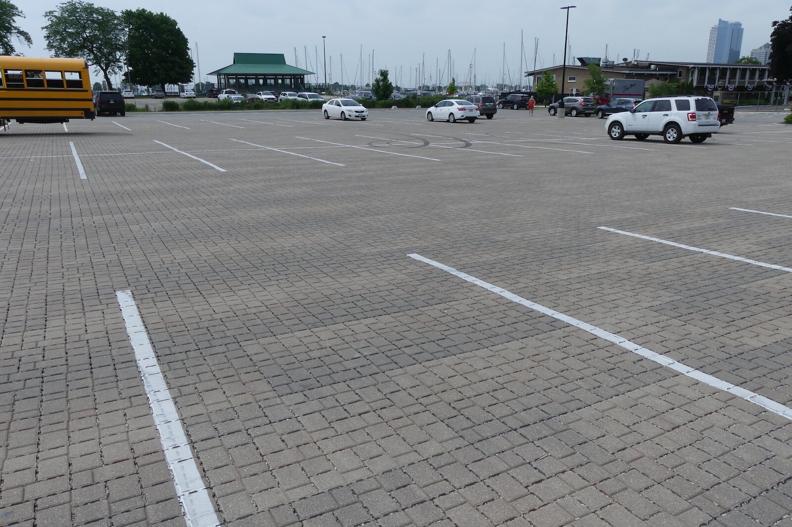
![]() The McKinley Marina porous pavement helps control water that otherwise would run off a parking lot. Photo courtesy MMSD
The McKinley Marina porous pavement helps control water that otherwise would run off a parking lot. Photo courtesy MMSD“Estimating probable maximum precipitation is used in the design of critical infrastructure like roads, bridges, wastewater treatment plants,” Vedachalam says “so this committee’s work is essential to further our understanding of the changing climate, so that all relevant agencies and local governments can design their infrastructure taking into account not just the changing climate, but the inherent uncertainty embedded within.”
“My hope is that state and local agencies look at the findings of this committee and realize that their current standards do not meet the needs of the future. I believe many of them already know this, but lack an objective basis to justify changing their standards or re-do some of the existing infrastructure.”
This is part of a series of stories based on the work of Environmental Consulting & Technology and Center for Neighborhood Technology and is underwritten by them.