This Town Needs…
Round Two of the Rapid Growth team's recommendations for a bigger, badder city.
Every month the Rapid Growth Grand Rapids Ideation Team (GRIT) — not a real thing — will share our ideas about what we think would make the great city of Grand Rapids even greater.
A Re-Imagined Riverfront
“Take me to the river.” – David Byrne
The recent flooding of the Grand River in downtown Grand Rapids was quite an eye-opener for many Grand Rapidians. For most of its residents, it was the highest levels they’ve ever seen the river reach. It reminded us all of what a powerful force it is in West Michigan, and how its very nature can affect the spirit of the entire region.
And yet, we continue to let downtown’s largest natural feature, a river and a riverfront that a lot of cities our size would love to have, not reach its full potential. We have a mishmash of river level trails that are closed most of the year or flooded in the spring, leaving large sections of the riverwalk in a disconnected, non-contiguous state. Dreams and plans of redeveloping certain sections of the riverfront, like the amphitheater area at the end of Lyon Street, have been put forward, but there’s been nothing bold and comprehensive.
When we ask our readers, Facebook fans, newcomers to the area, and speaker series attendees what they think is the number one area where downtown is lacking, they mention retail and not utilizing the riverfront.
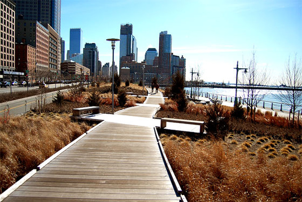
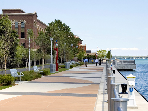
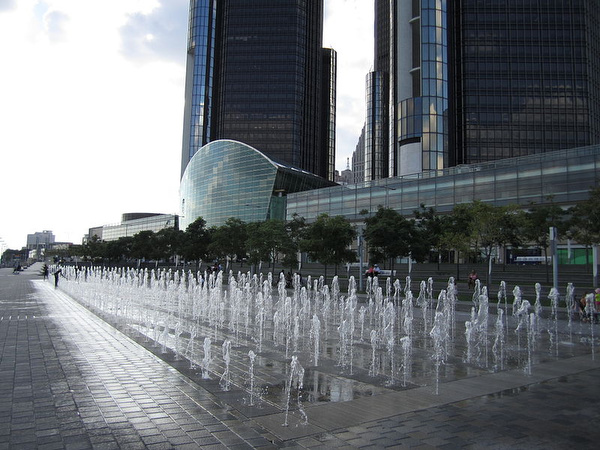
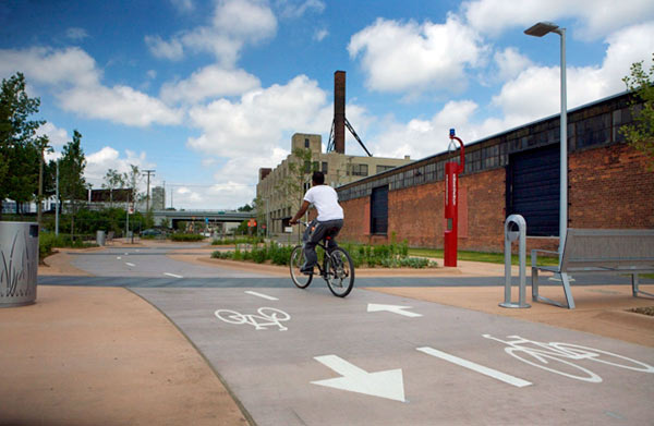
In Detroit, a public-private partnership formed in 2003 was able to raise funds and redevelop three continuous miles of the Detroit riverfront. Its esplanades, parks, amphitheaters, and biking and walking trails are world-class, and it is all maintained by the Detroit Riverfront Conservancy. If you haven’t visited the project, put it on your list of must-sees this summer.
In fact, in cities all over the country, riverfronts that were once used to power the industrial revolution are now being cleaned up and transformed into recreational meccas. They’re becoming a destination for weekend picnic-ers, wedding parties, power walkers and joggers, bikers and roller-bladers, and sand volleyball players.
The parties that are looking at restoring the rapids are on the right path, but to compliment their efforts, the City needs to think and act boldly with the riverfront.
And to make this easier on everyone, we’ve highlighted areas of the riverfront that need some attention on the attached maps. Not 10, 20 years from now. How about three to five years from now?
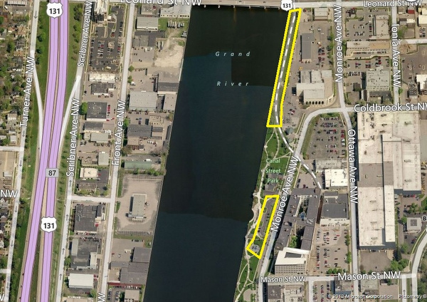
Map 1
We could go all the way up to Ann Street, but we decided to just concentrate south of Leonard to start. On the east bank of the river, thankfully, the work is already being done to transform this riverfront parcel near the water plant into an extension of the paved paths connecting to Riverside Park. Kudos goes to the DDA and Suzanne Schulz, planning director, for moving on this property. Add some signage that identifies it as part of the Kent Trails and White Pine Trail State Park and we’re on our way.
The parking lot at Canal Street Park — is this needed? Certainly, there are a few cars using it throughout the day, but it’s a big chunk of prime riverfront land to store cars on, with plenty of on-street parking nearby. What about recreational activities geared toward the hundreds of people who are now living in lofts on Monroe Avenue? Does the playground fit the area’s demographics? These questions should be asked of all the park’s amenities.
We’ll leave the west bank of the river north of Sixth Street area for another time.
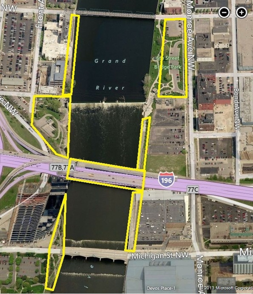
Map 2
The west bank of the Grand from Sixth Street down to the I-196 overpass could use some love. Plante Moran did a nice job of sprucing it up when they built their new offices, but more could be done by the City. How about some more trees and landscaping? Give it some continuity along the entire riverfront. The areas around the fishladder and up under the overpass look like they haven’t been touched in 30 years. Overgrown scrub brush that collects trash seems to be the theme in this area. “Come to Grand Rapids, visit the fish ladder, pay no attention to that trash.”
The east bank and Sixth Street Park were recently redeveloped, but again, is the massive parking lot necessary? With the distinct possibility of a new hotel going in across the street on Monroe Avenue (that will have its own parking), is there something that could be done with this area? Add in some infill development? Make the park bigger? Can we do better than surface parking lots?
The vacant lots on the east bank just north of I-196 are owned by a variety of parties, including the City, County, and now MSU College of Human Medicine. Is the city looking at design standards for any future developments as they relate to the river on these lots? We certainly hope so.
The riverwalk area by the central post office: tear it down and start over again. Serious traffic calming measures and an island would be excellent additions to the Michigan Street crossing over to the convention center.
The area in front of Bridgewater Place is promising. It could use some cleaning up near the I-196 overpass and also some serious traffic calming measures at the street crossing, particularly when the crossing under the bridge is flooded.
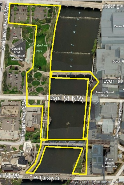
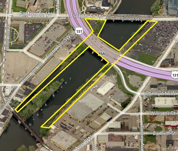
Map 3
The entire riverfront area from Bridge Street down to Fulton needs to pop! The design elements in front of the convention center are a good start, but continuing throughout the entire area. Are the parking lots on Bridge Street by the Gerald R Ford Museum needed? Cities all over the world covet their riverfronts. We park cars on ours. We can do better.
For anyone who spends time on the riverfront, even just at festivals, we don’t need to explain how uninviting the area under the Pearl Street Bridge is.
The Gillette Pedestrian Bridge? Put that on the list of rehab projects after the Blue Bridge is done. It used to be an interurban rail bridge (think streetcars), why not do something with it that gives a nod to its railroad past?
Conversely, the crumbling amphitheater on the east bank doesn’t make for a good visiting attraction for hotel and convention visitors. We’ve seen the redevelopment plans. What’s the hold up? And nix the giant chairs, please.
Bentham’s on the ground floor of the Amway Grand Plaza Hotel facing the river would be a great restaurant to have indoor/outdoor seating. Go crazy and make it a two-story restaurant with an all-glass atrium AGP!
Map 4
This is an area that could use a lot of help. On the east bank of the river, the riverwalk alternates from river level to elevated “above-the-seawall” level, and back again. It’s estimated by the Rapid Growth staff that the “Closed for the Season” signs are posted for more months than not. So why not make the entire riverwalk elevated on that side? Think “High Line” of New York, from Pearl Street down to the Blue Bridge. Evening strollers walking past diners at the JW Marriott. We can picture it. Can you?
The west bank of the river near the Blue Bridge and the Public Museum may be one of our favorite spots, and judging by how many people hold outdoor weddings there, we think a lot of people would agree. But again, the lower sections are susceptible to flooding, and the transition area from the riverwalk up to the Blue Bridge is dated. Do-over!
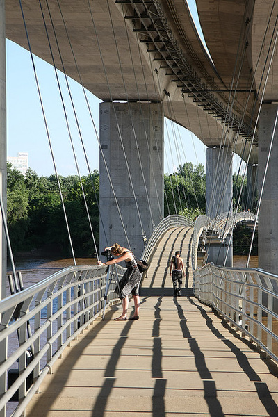
Continuing on the west bank, the opening of GVSU’s Seidman College of Business has opened a whole new set of opportunities to stretch the riverwalk beyond the S-curve. Key additions would again be traffic calming measures on Fulton on both sides of the river, and a connection of the west bank to the east bank. Richmond, VA decided to hang a pedestrian bridge to the underside of a highway bridge. Could we hang one under the S-Curve?
An important thing to keep in mind is that recreational (and physical fitness) users of trails and riverwalks like to move in circuotous fashion. That way, the trip back isn’t exactly the same as the trip out. Make the end goal of this whole project a loop around the river from south of the S-curve to Ann Street, and we’ll have a world-class attraction on our hands.
As far as the privately owned parcels along these areas, we just hope they do something soon, treat the river as the asset it is, and solicit public input into the process.
Just don’t let the riverfront continue on its current path. Literally, and figuratively.
Onward and upward!
P.S. If you think we’ve missed anything obvious, please let us know in the comments below.
Some photos courtesy of the Detroit Riverfront Conservancy.
Related Articles
Equest Center highlighted as Bank of America boosts year-round community support
Bank of America’s Day of Giving showcases its ongoing volunteer partnership with Equest Center; Lakeshore Advantage selected as bank’s 2025 Neighborhood Builder.
Retailer Hank Meijer shows off his storytelling talents at Dutch American celebration
At Dutch-American Heritage Day, retailer leader and author Hank Meijer reflects on family stories, immigrant roots, and the legacy of Fred and Lena Meijer.

It’s hard for foster kids to get the health care they need, but this project is working to change that
A Grand Valley State University project is working to create an integrated mobile care team to serve foster kids’ complex health needs.